A million BirdGuides records migrate to BirdTrack
BirdGuides and BTO have been working closely together since early 2010. One important outcome of this exciting collaboration has been the sharing of the BirdGuides archive of bird records with the BTO database via BirdTrack, making these data available for conservation and research programmes.
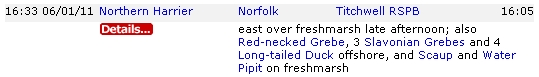
Whilst this may sound simple, transferring such a large volume of data between two different systems proved a major challenge. We also wanted to maximise the value of the BirdGuides data by capturing the incidental records of species such as the grebes, ducks and Water Pipit in the example below. Thanks to the combined efforts of our database managers and programmers we've recently uploaded a massive 998,280 records from 15,139 sites across Britain and Ireland, including many supplementary records of commoner species.
Screenshot from Bird News Extra illustrating the number of incidental records needing to be captured.
We will soon also be running an automated nightly upload, so at some undesirable time of night the BTO server will call up records from the BirdGuides server and automatically load them, making them available the following day. They will then be viewable via the standard results pages in BirdTrack, bringing a wealth of records of scarce and rare birds, extralimital birds and extreme migrant dates into the system. They will also feed into the wider bird recording network by being immediately available to a variety of conservation projects and the network of county recorders who already download records from BirdTrack, helping to ensure that BirdGuides' records are 'put to work'.
One immediate benefit is that these records can now feed into the Bird Atlas 2007–11. The next logical step was to identify just how many of these uploaded records could potentially add a 'dot to the map' for this project and how to go about making this happen. Initially we concentrated on winter records because they all have the potential to add dots, unlike in the breeding season for which records lack the breeding evidence that's vital for the Atlas. We were amazed to find that the number of potential dots that could be added at the 10-km level was 8,008!
The BirdGuides winter records came from 3,322 sites and a team of volunteers are now defining these sites to a tetrad or 10-km square wherever possible, so as to assign each record to the correct square on the map. The likely value of these additional records is strikingly obvious in some of the species maps. For example, the provisional map for Iceland Gull really highlights the contribution BirdGuides records can make, particularly for central England and the south and southwest coasts, whilst clearly showing the importance of dedicated Atlas fieldwork in areas such as the far north of Scotland and around the Irish coastline.
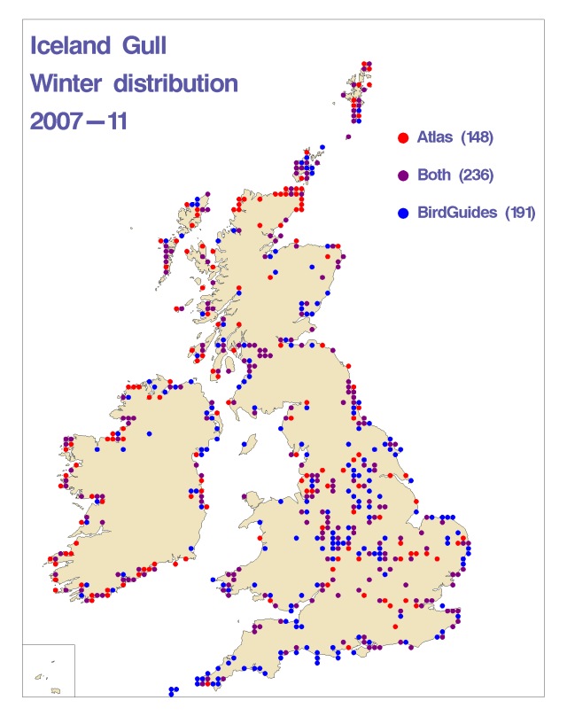
Preliminary map for Iceland Gull, showing the additional contribution of BirdGuides records.
Red dots: Records from the BTO database.
Blue dots: Potential additional records from BirdGuides database.
Purple dots: Records from both the BirdGuides and BTO databases. (Map: BTO.)
There are a number of good birding sites that don't fit entirely within one 10-km square. Unfortunately the Atlas cannot use BirdGuides records from these sites as it is not clear which is the appropriate 10-km square. Good examples of sites that straddle 10-km boundaries are Rutland Water, Breydon Water and Chesil Beach. We encourage you to submit records from sites like these as Roving Records so that they can be included in the Atlas.
We are also not uploading unconfirmed reports or possibles/probables, and are 'cleaning' the myriad of permutations of bizarre and unusual records. These include records of birds that were re-identified (sometimes more than once!), such as this Norfolk Sylvia warbler:
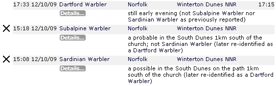
Screenshot from Bird News Extra of a confusing Sylvia warbler.
Crucially, BirdGuides records will be subjected to the usual rigorous Atlas validation process to ensure grid references and identifications are correct. Rough-legged Buzzard is a good example. Being a local rarity in many regions, records of this species will need to be assessed and accepted by local rarities committees before they are validated for the Atlas and the same is true of records of national rarities (via assessment by the British Birds Rarities Committee). If you recognise one of your own records on the map below, or have sent in reports of any other local or national rarities, please submit a description to the relevant committee if you haven't already done so.
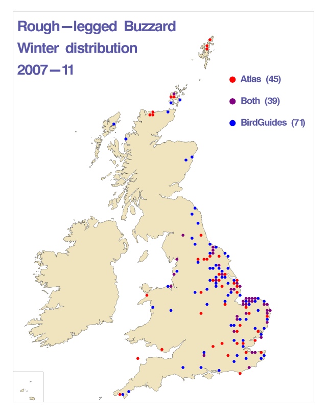
Preliminary map for Rough-legged Buzzard, showing the additional contribution of BirdGuides records. (Map: BTO.)
As the final winter of the Bird Atlas project is rushing past, these records will help to target effort in the final stages of this important project. So next time you send in a sighting via text, email, 'phone or submit online, you can rest assured that BirdGuides is providing much more than just a news service by putting something back into bird recording.
